From Central London: 1.3 miles (2.0 km)
nearest
Tube Station: Lambeth North 0.4 miles (0.7 km)
Railway Station: London Waterloo 0.6 miles (1.0 km)
Motorway: M4 Junction 1, 6.9 miles (11.1 km)
Hold down your left mouse button down while clicking on the map, keep it held down to move the map around.
Use the + and - symbols on the maps left bar to zoom in and out..
Click an icon to view hotel information
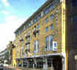
Directions: 1 minute from the South Bank of the Thames river, opposite Big Ben and Westminster. 10 minutes walk from Westminster and 5 minutes drive from Waterloo International railway station.
Nearest tube (Underground) stations are Westminster (Circle, District and Jubilee lines) and Lambeth North (Bakerloo line).
Buses No.77 and 507 run to Waterloo International station, C10 to Victoria Station and No.3 to Westminster, Piccadilly Circus and Oxford Circus.
 From Central London: 1.3 miles (2.0 km)