From Central London: 0.5 miles (0.9 km)
nearest
Tube Station: Charing Cross 0.1 miles (0.2 km)
Railway Station: London Charing Cross 0.2 miles (0.3 km)
Motorway: M1 Junction 1, 6.4 miles (10.4 km)
Hold down your left mouse button down while clicking on the map, keep it held down to move the map around.
Use the + and - symbols on the maps left bar to zoom in and out..
Click an icon to view hotel information
Directions:
By Road: From Trafalgar Square or Parliament Square, take the exit to Whitehall.
Turn into Whitehall Place, then right into Whitehall Court. Masterpark car
parking is available nearby at an additional charge.
By Rail/Tube: The hotel is two minutes from Charing Cross Rail Station and
Waterloo is three kilometres away. The nearest underground stations are
Embankment, on the Circle, District, Bakerloo and Northern lines, and Charing
Cross, on the Bakerloo and Northern lines.
By Air: Heathrow Airport is just over twenty five kilometres east. Gatwick
Airport is forty five kilometres north.
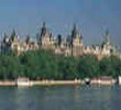 From Central London: 0.5 miles (0.9 km)