From Central London: 3.6 miles (5.8 km)
nearest
Tube Station: Dalston Kingsland 0.2 miles (0.4 km)
Railway Station: Dalston Kingsland 0.2 miles (0.3 km)
Motorway: M11 Junction 4, 5.9 miles (9.5 km)
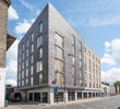
Address: 25-27 Dalston Place, London, E8 3D, England
Hold down your left mouse button down while clicking on the map, keep it held down to move the map around.
Use the + and - symbols on the maps left bar to zoom in and out..
Click an icon to view hotel information
Directions: Following from A406 to A10 on Kinglsand High Street, exit left on A104 and the hotel will be 178 yards on the left. Exit the A12, following on B112 towards Hackney after 1.1 miles. Turn left on to A1207, continue towards A104 the hotel is on the right, 178 yards. Local pay and display car park is Bentley Road which is within 5 minutes walk to Dalston Lane.
 From Central London: 3.6 miles (5.8 km)