From Central London: 2.2 miles (3.6 km)
nearest
Tube Station: High Street Kensington 0.3 miles (0.5 km)
Railway Station: West Brompton 1.1 miles (1.8 km)
Motorway: M4 Junction 1, 4.1 miles (6.6 km)
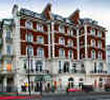
Address: 60 Hyde Park Gate, London, England, UK, SW7 5BB
Hold down your left mouse button down while clicking on the map, keep it held down to move the map around.
Use the + and - symbols on the maps left bar to zoom in and out..
Click an icon to view hotel information
Directions:
By air
From
London Heathrow airport, take the Heathrow Express train from London Heathrow to Paddington railway station.
From
Gatwick airport, take the Gatwick Express from London Gatwick to Victoria station.
From
Stansted airport, take the Stansted Express from London Stansted to Liverpool Street station.
By train
Underground station:
High Street Kensington
By car
From London Heathrow airport, take the M4 towards the centre of London, approximately 20 km away. Cross Hammersmith and pass the Novotel on your left, take the left lane and after approximately 2 km turn onto Warwick Road, where you will see the Tesco supermarket on the left. At the third traffic lights, turn right onto Kensington High Street and continue for approximately 3 km. The Baglioni Hotel London is on your right approximately 350 metres after the High Street Kensington underground station. The hotel entrance is at Hyde Park Gate, opposite the park and Kensington Palace. From Gatwick airport take the M23 North until you reach the M25. Travel in a clockwise direction on the M25 towards Heathrow and the M4.